VT SuperDARN
Login
Register
News
VT
VT Technology
SuperDARN
Student Opportunities
Links
Space Weather Portal
Calendar
VT Home
VT ECE Home
Space@VT
SD Pub List
SWF Monitor
Suggestion Box
Contacts
Personnel
Contact/Visit US
Quick Browse
Daily Multi-Radar Plots
Range-Time Plots
Convection Maps
Daily GeoActivity Plots
Interactive Plots
RTI
Fan
Map
Radars
Radar Pages
Radar Hardware
Realtime Data
Data Acknowledgements
Register/Login
Register
Login
SuperDARN Resources
Quick Start Guide
.word-wrap{word-wrap: break-word;}
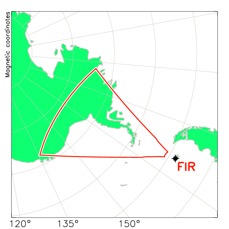
Falkland Islands
FALKLAND ISLANDS (51.83 S, -58.98 E) The Falkland Islands SuperDARN radar has had two operating periods: February 2010 until September 2011 and November 14, 2017 to the present. The site is operated by the British Antarctic Survey. During the first period the control electronics were borrowed from the Halley radar while the Halley site underwent one of its periodic rebuilds and Dr. Mervyn Freeman was PI. During the current period Dr. Gareth Chisham is the PI. The Falkland Islands radar provides the lowest latitude data ever collected by a SuperDARN radar. Its field of view is conjugate to those of the Wallops and Blackstone SuperDARN radars in the north. A note from Gareth dated May 18, 2020: 'There is presently no SuperDARN radar operating at Halley. Since the Brunt Ice Shelf started collapsing a few years back there have been no overwintering staff at Halley for the last few years for safety reasons. At the time that we went to summer-only operations there was no possibility of running the radar remotely over the winter because of the lack of power over winter. So we removed all the electronics to the Falkland Islands and restarted the radar there. Although we now have autonomous power through the winter at Halley now, due to a new microturbine system, the system is still not stable enough for us to consider sending the SuperDARN radar back there. There are lots of other space weather instruments at Halley that have restarted operation though. We are actually looking at alternative sites in the Antarctic to send the radar back to where there is less snow accumulation, and hence, less yearly maintenance needed. This is probably still a few years away though. The re-sited radar in the Falklands is going from strength to strength though, with a new operating system and STEREO operation. Hopefully this will put it in a good place for when it does actually head back to the antarctic mainland.' Notes: Beam Separation Sign: Northern hemisphere radars count beam 0 as the westernmost beam, which is the leftmost beam. Historically southern hemisphere radars did the same westernmost, which is the rightmost beam, meaning the beam separation would be negative. This is why the beam separation for FIR is negative. Moving radars: The Halley radar was turned off December 15, 2007 and dismantled in order to be relocated with the rebuild of the Halley BAS station at another location. (These moves are carried out periodically owing to the advancing ice sheet.) As the building was going to take several years to complete, it was decided to operate the radar from a site in the Falklands, thereby providing mid-latitude measurements that are conjugate to mesurements made by the northen mid-latitude radars (Wallops, Blackstone). A site was found in the Falklands and an array of antennas built. The Halley electronics powered the system from a shed. Now the electronics have returned to Halley station to be incorporated in the rebuilt radar, which resumed operation on February 24, 2011. It is hoped that a new set of electronics can be lined up to return the Falklands site to operation. The Falklands Islands SuperDARN radar operated from February 2010 until September 2011.
Download Falkland Islands Hardware File